
// BOAT DOCK AT KARAKOY
INTERVENTION ONE
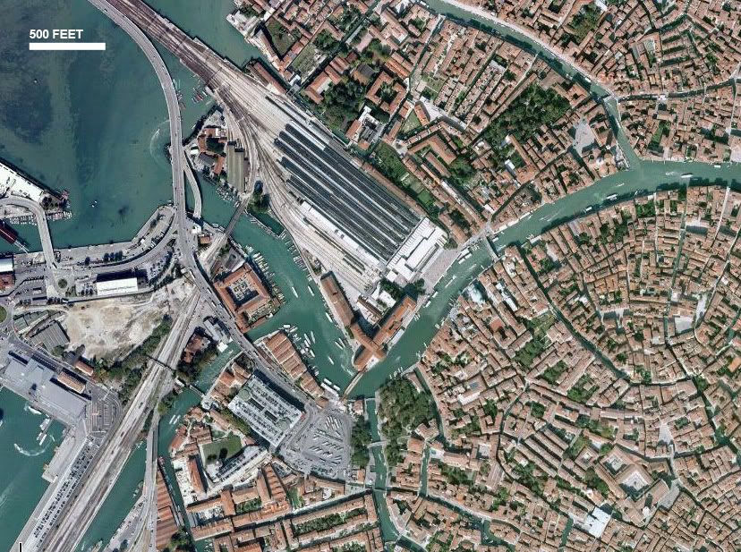
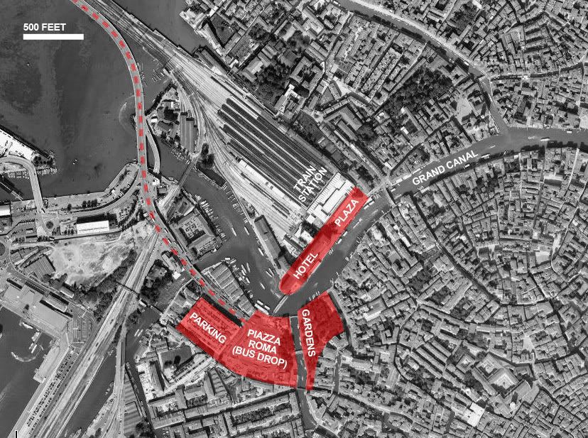
VENICE : PIAZZA ROMA

// VIEW DOWN THE GRAND CANAL, NEAR PIAZZA ROMA
Venice is considered by many to be one of the most beautiful cities in the world. Much of its charm is due to the visual unity of the city. It is difficult to imagine adding something new to Venice without damaging its carefully kept coherence. Calatrava tried not so long ago, receiving a good deal of criticism (and lawsuits).
There is a highly prominent site, however, that most would agree stands out like Venice’s sore thumb. For hordes of tourists and locals, Piazza Roma marks the entrance and exit to Venice. It serves as the spot furthest into the island that an automobile can travel (which isn’t very far at all). Piazza Roma has thus developed as the natural location for the bus drop off and parking garages.
Most people that are confronted with Piazza Roma quickly move along and do not think about it again until they need to find a bus off the island. It really doesn’t seem to be part of Venice at all, just an infrastructural necessity unworthy of anyone’s attention. Given the piazza’s location and function, however, it has enormous potential to be an important landmark for the city. As a bookend to the Grand Canal (opposite the iconic Piazza San Marco on the eastern end) Piazza Roma feels ill-defined and anemic. It is a weak terminus that does little to confront the major event that it denotes. For many people, it is their first introduction to Venice and it is literally a parking lot.

// CLICK HERE TO ENLARGE

// CLICK HERE TO ENLARGE
PIAZZA ROMA : OPTION A
Venice would do well to rethink the function of Piazza Roma. It can retain its function as a hub for transportation while growing into a multifaceted space inviting pedestrian activity to linger. The piazza can be transformed into a destination, rather than accepting its current status as merely a stop on the way to Venice proper.
Venice is a city of pedestrians. Piazza Roma presently falls into the opposite extreme, but this does not need to be the case. Bolstering a stronger connection between the piazza and the Grand Canal would be a large step in the right direction. Orienting views toward the canal, or even overtly framing them, would lay the foundation for a piazza that addresses the larger context that it is situated in. Piazza Roma should embrace its position as the natural entrance (or terminus) to the Grand Canal. The piazza should celebrate its unique relationship to the city, rather than defer to the grandeur of the canal.
A new Piazza Roma could employ outdoor spaces and restaurants that actively orient themselves toward the canal. They would not need to front directly on the water to take advantage of it. Given the necessity for multiple stories on the site (retaining the parking garage and bus drop-off inevitably leads to this condition) the elevated nature of some elements could present opportunities to capture great views of the city.
However, proper orientation and good views alone would not bring Piazza Roma up to the status its location deserves. There needs to be a healthy mix of pedestrian programs to keep people engaged with it. A pitched park space (perhaps including an outdoor theater) interspersed with shops, gelato stands and restaurants might be a valid mix. The piazza is a natural candidate as a meeting spot and could benefit from programs such as these.

// CLICK HERE TO ENLARGE
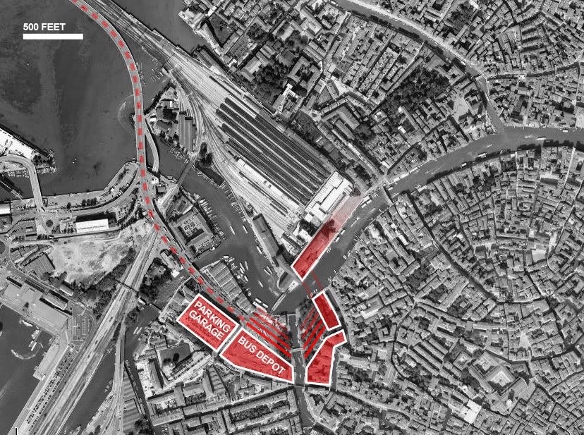
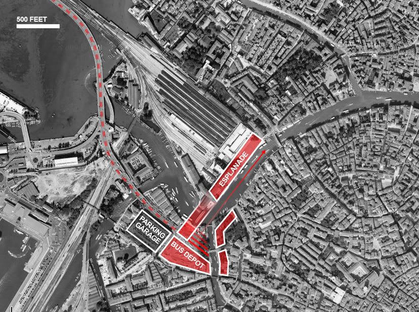
PIAZZA ROMA : OPTION B
A second method to better integrate Piazza Roma into the city would be to reinforce an axis along the main thrust of the Grand Canal that links back into the piazza. This axis would be established as an esplanade that originates at Piazza Roma, spans across Calatrava’s bridge, continues along the water, and connects into the plaza in front of the train station.
This strategy, with a focus on an esplanade rather than a square, would have very different implications for Piazza Roma. It would certainly clarify and strengthen the connection between the piazza and the city. However, it might have a harder time establishing a sense of place that one feels more comfortable utilizing as a space to spend time. The geometry would likely promote pedestrians to proceed along it as opposed to lingering.
This strategy, however, has the opportunity to reinforce a strong path of movement, spanning from the bus drop and parking garage to the central armature of the city (the Grand Canal). The intervention would treat Piazza Roma as a path rather than a node. Building along an axis would give visitors a clear procession into the island, replacing the amorphous nature of Piazza Roma as it is.

// CLICK HERE TO ENLARGE
INTERVENTION TWO
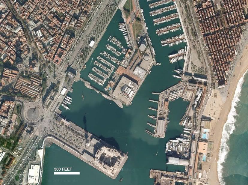
BARCELONA : PORT VELL

// RAMBLA DE MAR AT PORT VELL
In the last two decades, Barcelona’s central waterfront has been rejuvenated through an extension of one of the city’s dominant urban features: La Rambla. A new pedestrian bridge, Rambla de Mar, spans across the harbor to link the mainland to a pier that has been converted to an entertainment and shopping center. The old pier has been revived as a popular destination and attracts tourists and locals alike.

// CLICK HERE TO ENLARGE

// CLICK HERE TO ENLARGE
PORT VELL : OPTION A
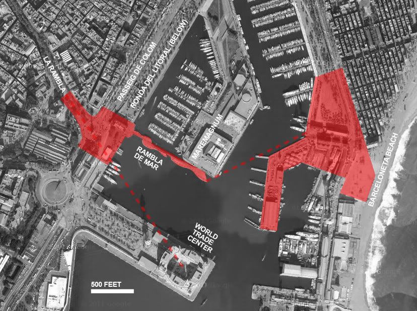
Barcelona’s new waterfront is certainly successful on many counts, but it misses some significant opportunities. One option would be to continue this extension of La Rambla further, connecting to Barceloneta Beach, just across the harbor. Rather than relying on the creation of new public space, as the redevelopment of the Port Vell pier did, this area of beach is already a vibrant district and major pedestrian attraction. A more direct route to La Rambla and the city center would create a very strong axis of pedestrian movement for Barcelona. It would play to the strengths of both the axial clarity of La Rambla as well as the active pedestrian nature of the beach. The new connection would take heat off of the more circuitous route to the coast and strengthen the hierarchy of movement paths through central Barcelona.
If done carefully, this new path could deviate slightly off axis to adhere to the geometry of an existing pier across the harbor. This would cause the path to land in the center of two major squares on the beach side. The bend would also mitigate the issue of monotony that could arise from too long of a straight distance over the harbor.
 // CLICK HERE TO ENLARGE
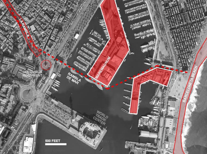
PORT VELL : OPTION B
Another strategy could be a more literal extension of La Rambla, where, rather than any deviation from its strong axis, the path over the pier extended straight from La Rambla’s southern terminus. This geometry would bring the opportunity of a connection to Barcelona’s World Trade Center before angling toward Barceloneta. The advantage of this option is the creation of a clear connection to La Rambla that is lacking with the current Rambla de Mar. However, a connection to the World Trade Center would not be as appropriate as the current one to the Maremagnum shopping center on the newly developed Port Vell pier. Ideally, the strong relationship with La Rambla could be kept without sacrificing the proper pedestrian program. This desire puts weight on the role of the traffic circle at the Columbus Monument. This is the site where the end of the current axis of La Rambla needs to be better transitioned to the waterfront and beyond.

// CLICK HERE TO ENLARGE
INTERVENTION THREE
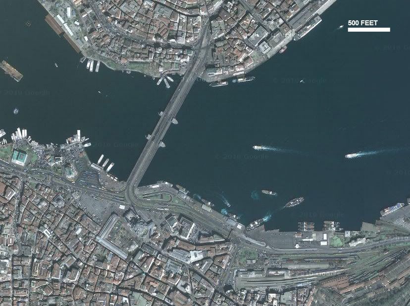
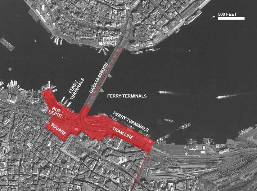
ISTANBUL : EMINONU

// EMINONU, FROM THE BASE OF THE GALATA BRIDGE
Eminonu is considered by many to be the epicenter of action in Istanbul. The neighborhood, namely in the area where the southern end of the Galata Bridge meets land, is a major hub of transportation for the city. Ferry docks, the central train station, heavy automotive traffic, the tram line, and numerous bus stops are all woven into the zone along the shore at Eminonu. Pedestrian activity, however, is in no way deterred from the area. In fact, the density of foot traffic rivals any part of Istanbul. A major public square, divided from the waterfront by the road, enjoys constant use.

// CLICK HERE TO ENLARGE

// CLICK HERE TO ENLARGE
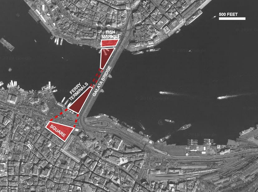
EMINONU : OPTION A
Athough Eminonu manages to negotiate a plethora of infrastructural systems, one gets the sense that it might be ready to burst. Often, urban spaces have the opposite issue and need to be rethought in order to draw attention to them. The waterfront at Eminonu, however, would be well served to disperse its popularity. The density of traffic becomes unwieldy at times.
Using the bridge as an armature, public spaces can be extended out over the water. More open space will help to mitigate the extreme concentration of activity on the square. A connection across the road will also need to be strengthened. The subterranean tunnels that allow foot traffic from one side of the road to another are already not sufficient for the number of people moving across. A more radical method of crossing the road, whether under or over, could be instituted to alleviate the congestion and allow the square to spill over to the waterfront more fluidly. This will benefit both.
Building away from the shore should be done carefully, as not to disrupt the views from the bridge. The new program should also compliment those already found on the bridge (restaurants, fishing) rather than replace them. Given the popularity of the location and the abundance of established programs, an intervention heavier on open space and lighter on program might be in order.

// CLICK HERE TO ENLARGE
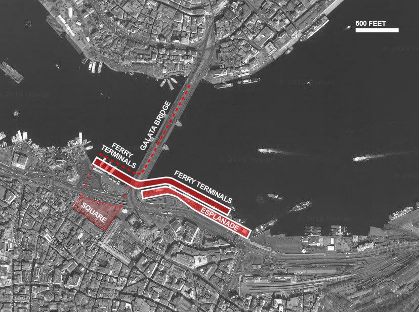
EMINONU : OPTION B
If disrupting the function of the bridge is too a large concern, another strategy is to expand the waterfront laterally. More space can be layered onto the edge of Eminonu, both in plan and in section. This should be done without sacrificing too much view to the water. The play in section can also incorporate the ferry docks and waiting rooms more cohesively than they are now.
This strategy would open up more space for movement along the waterfront, where it is currently compressed in the same area as the ferry docks. An additional layer of space would serve as an outlet for foot traffic and take pressure off.
Adding space to this location presents an opportunity to weave more pedestrian-friendly programs. Unlike layering new spaces onto the bridge, more park-like spaces and restaurants (if integrated carefully as to not disrupt much waterfront view) could improve the area. The goal is to take the success of Istanbul’s waterfront at Eminonu and craft it into a coherent and structured blend of public space and infrastructure.

// CLICK HERE TO ENLARGE
Leave your comment