
THE IMAGE OF VENICE
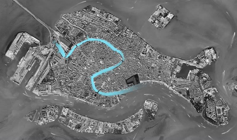
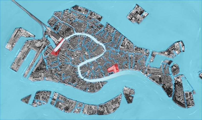
What is the image that structures Venice? Ultimately, it hinges on the dominance of the Grand Canal. Its serpentine path carves a corridor through the city that is easily perceived both from the air and the ground. The Grand Canal is the artery that the city’s many paths feed into.

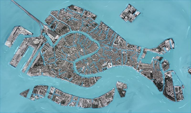
// GROUND VERSUS WATER IN VENICE
CLICK HERE TO ENLARGE
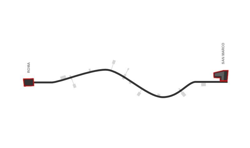
How then can the image of Venice be strengthened? The primary focus should be to reinforce the Grand Canal as legible object. It should be easily observable as a path from point A to point B. Considering it as a path from west to east, Point B is clearly Piazza San Marco. Although the piazza opens off the side of the canal, it is the grand event that terminates the path and demarcates the transition from canal to the open water of the lagoon.

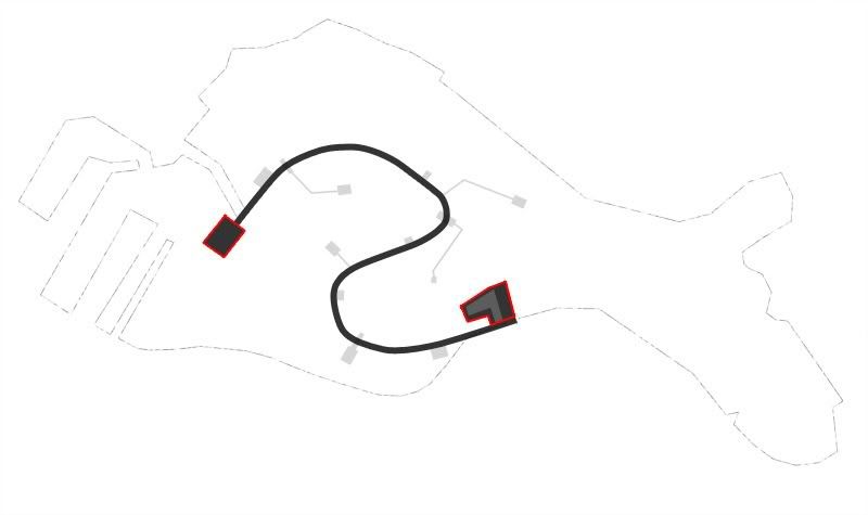
// THE GRAND CANAL
CLICK HERE TO ENLARGE
Over the length of the Grand Canal, the clarity of its dominance goes unquestioned. It enjoys a marked contrast in scale from its context that is immediately recognizable. The Grand Canal needs no help in this department. Its terminus at the western end, however, lacks this same clarity. The train station and adjoining plaza make an attempt at playing the role of “point A,” but do not adequately capture the canal in a meaningful way. The station does not have the urban heft of Piazza San Marco (at the opposite end), nor the geometric advantage to be an obvious terminus to the canal. Instead, the canal glides by the station and meets an urbanistically noncommittal juncture of paths as if it can’t decide what to do next. This area, therefore, is an excellent site for an intervention that can strengthen the image of Venice.

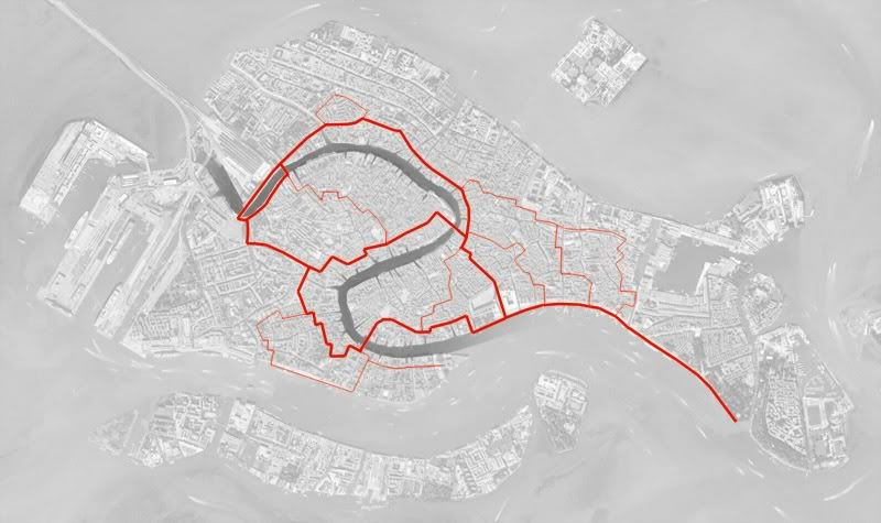
// HEAVILY TRAVELED PATHS IN VENICE
CLICK HERE TO ENLARGE
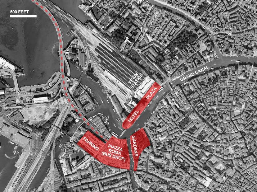
THE SITE
For the western end of the Grand Canal to be as legible as the eastern, a major event is required. Presently, there is a paved lot used as bus and taxi drop-off located at a noticeable kink in the canal just southwest of the train station. This site, known as Piazza Roma, is a large, flat, and relatively undifferentiated surface that stands in stark contrast to the dense and rich texture of Venice.

// HARDSCAPE OF PIAZZA ROMA

// COMPONENTS OF THE SITE
CLICK HERE TO ENLARGE
Both the function and position of Piazza Roma gel with a potential role as the western bookend of the Grand Canal. As a drop point for a great many people entering and leaving the city, the site can seamlessly transition the experience from automobile to a pedestrian trajectory down the Grand Canal. Piazza Roma is in fact the furthest into the island that an automobile can travel. This is the opportune point for an urban event to announce the importance of the place and clarify the transition from roadway to waterway.

// EXISTING SITE
The site currently makes little to no gesture at all, leaving one to orient themselves to the city without assistance from their environment. By rethinking Piazza Roma as a substantial event that formally marks the end of the canal, Venice can complete its diagram and greatly boost its imageability.

// PATH OF GRAND CANAL WITH BOOKENDS
CLICK HERE TO ENLARGE

// SKELETON OF VENICE'S IMAGE
CLICK HERE TO ENLARGE
URBAN STRATEGY
Given its prominent and strategic location, the Piazza Roma site has an opportunity to take on a greater, more active role in the city. It is a hub for transportation, but does not need to be a space merely to pass through. The piazza should be treated as a destination. Although the primary function of Piazza Roma is as a drop point for buses and taxis (and this should remain the case), a wealth of new programs may be introduced as well. These should be pedestrian oriented programs, such as restaurants or park space. The site can be a place to spend time, rather than one to pass through and forget. This would concentrate activity at the site and help promote its stature within the collective image of the city.
A new Piazza Roma could bypass the kink in the canal by actively grabbing the space in front of it, thus reinforcing an axis that leads directly down the canal. This will also establish what is considered as the “front” of the plaza and give it an orientation that addresses the canal. There will no longer be a kink in the canal. Rather, this point will mark its formal beginning (or ending). The objective is not to literally terminate the flow of water at this point, but only to define the space and urban condition in a clear manner.

// A NEW PIAZZA ROMA COMPLETES THE CANAL
CLICK HERE TO ENLARGE
Of course, to address one direction of the canal is turn your back on another. However, Piazza Roma is located in such a position that the area to the northwest that this intervention would cut off is in no way an active pedestrian zone. It is already programmatically and architecturally disparate from the bulk of the city. Piazza Roma marks the beginning of pedestrian Venice and (what would now be considered) the well established beginning of the Grand Canal.

// FORM OF THE INTERVENTION
The pedestrian axis adjacent to the canal must also be strengthened. This axis serves as a path of movement from Piazza Roma, northeast across the canal, along the waterfront, and to the plaza in front of the train station. It is an extremely heavily traveled path and should be given a clearer prominence. It will also serve as one of the arms bounding the space that defines the terminus of the Grand Canal. The strong continuity of this axis across the canal is important to its legibility.
A new Piazza Roma would hold a great responsibility in orienting paths of movement, directing views, and resolving the geometry of the canal in order to clarify the structural image of Venice.
Leave your comment